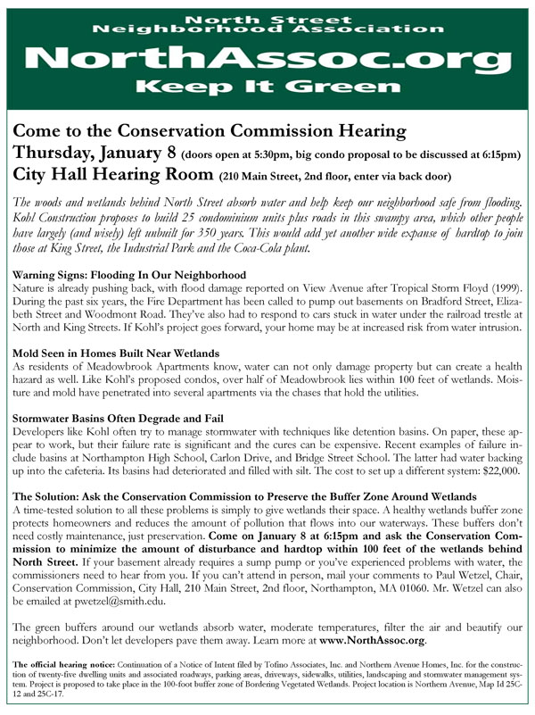
We are distributing this flyer to the North Street neighborhood. Download it as a PDF. Join us on January 8 and let the Conservation Commission know a developer’s profits must be balanced with our safety, quality of life, and the health of our environment.

See also:
Kohl Construction Applies for Special Permit and Site Plan Review
(11/20/08)
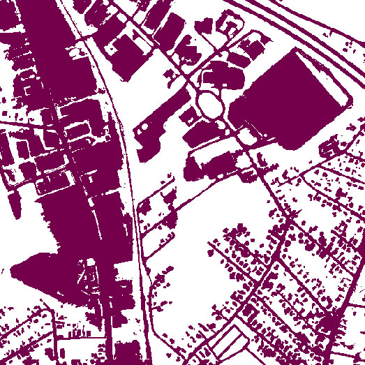
Topographical Map Shows How Kohl Condo Proposal Will Eat Into a Rare Stand of Mature Trees in Downtown
The
following view dramatizes the considerable amount of impervious surface
already in the area, especially around King Street and the Coca-Cola
plant. Kohl’s “infill” project will convert a significant amount of the
remaining greenspace to impervious surface. The presence of Millyard Brook shows that this area serves as a natural sink for water in the neighborhood.

Northampton’s
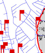
Flood and Natural Hazard Mitigation Plan: Floyd Flood Damage Reported
Behind View Avenue; Avoid Building on Filled Wetlands
In the map
below, the red flag behind View Avenue (the topmost flag) indicates a
flood damage report from Tropical Storm Floyd (1999). This area is in
the eastern portion of Kohl Construction’s proposed condo site, one of the more elevated portions. We infer that much of Kohl’s property may be at risk from heavy rainfall events.

Flooding Incidents in the North Street Neighborhood: 2003-2007
Letters from Residents Describe Groundwater and Sewage Issues Around North Street
Video of December 11 Kohl Condo Hearing at Conservation Commission
Kohl proposed to place grading, walls, yards, patios, and certain components of the stormwater
management system as close as 12 feet to the wetland
on its parcel… The commission expressed discomfort with allowing much disturbance closer than 35 feet to the wetland…
…Commissioner Downey Meyer, “I’m…not inclined to go below 35
feet. I also wonder why those who have spoken so quickly got to 50,
since the state Wetland Protection Act and the city ordinance both
protect to 100. So I think you’re being rather unambitious arguing from
50 to 35… I’m also, as Alex said, a little bit skeptical of the
engineered solutions… Part of the reason why buffer zones have
received greater emphasis in wetlands protection is that they do seem
to work without anyone having to maintain them in terms of making the
whole wetlands system work effectively.
The Republican: “Neighbors challenge developer’s plan” (12/12/08)
In
the first test of the city’s new wetlands ordinance Thursday, the
Conservation Commission drew the line at 35 feet for encroaching into
wetlands, sending developer Douglas A. Kohl back to the drawing board.
Kohl
wants to build 25 townhouse units in a wooded area near North Street
and Northern Avenue. Neighbors oppose the project, saying that it will
adversely affect wetlands there and carve up one of the last remaining
undeveloped parcels near downtown…
Some 25 people, most of
them residents of the North Street neighborhood, jammed the hearing
room at City Hall. Many said their basements flood and fear further
development will exacerbate flooding…
Video: School Committee Meeting of December 11; Regionalization Discussed
Funding Approved for Bridge Street School to Address Flooding
Problems: Process Stormwater with Sewer Tie-in Rather Than Detention
Basins
1:42:55-1:43:33
“Bridge Street School has an issue
with flooding because of the detention basins which are underground
there. And every time we get a downpour we have issues of flooding in
the cafeteria and then up that hallway. This will help tie into the
city system, rather than have the water go into these detention basins
which are supposed to then have the water percolate down into the
groundwater. So this will be a major improvement for Bridge Street
School.”
City of Northampton, Memo from Mayor Clare Higgins to City
Councilors, “FY 2009 Capital Improvements Program Recommendations”
(12/4/08)
Bridge Street School – Detention Basin/Sewer Tie-in – $22,000
Repairing the three dry wells at Bridge Street School was ranked as the
[Northampton Public Schools’] second highest priority. The wells are
filled with silt and the ground water backs up into the building. The
DPW has cleaned the wells but the problem still exists due to the lack
of slope and the deteriorated condition of the wells.
Alex Ghiselin, Letter to Gazette: “Don’t let development encroach on our wetlands”
The
failure of the storm water system built as a part of the Northampton
High School renovation six years ago illustrates why protecting
wetlands is so important. Silt has filled the retention pond so there
is no capacity to slow a storm surge which now flows unimpeded into the
Mill River and contributes to flooding downstream. This accumulated
silt also raised the water table and spills ground water into nearby
basements…
Without maintenance, these [storm water mitigation] systems are part of the problem, not the solution…
Wetlands do not need to be maintained; they just need to be protected.
Carlon Drive: Compensatory Wetland Not Working
Mike Kirby writes:
In
Carlon Drive, they simply scooped out a hole in the swamp-bottom, and
called it a detention structure. Today it is just a pond, and a
stagnant smelly one. It was designed to have a dry forebay, and a
shallow main chamber was supposed to have only about 6 inches of water
in it. This was supposed to be a compensatory wetland, full of cattails
and wildflowers. A rock check dam was supposed to hold back the “first
flush” off the parking lots and trap pollutants, and outflow from it
was supposed to feed the wet part of the detention pond. Here rain
water pouring off the new parking areas and street was supposed to be
stored, and discharged safely.
That was the plan. Today if you
stand by the pond and look down into it, you’ll see the check dam is
now about two feet underwater. You can’t even see where they planted
the marshgrass and flowers. The area is under water. Even in a fairly
dry summer, the detention pond is only about a foot and a half from the
top of the bank. There’s no storage to speak of, no discharge, no
filtering. As it is constructed now, grey water from the parking lots
and the access street goes directly into the swamp and the Connecticut
River.
Photos Show: Man-Made Lakes and Stormwater Retention Systems
Are No Substitute for Natural Wetlands
Maintaining Stormwater Management Systems
“The
number-one problem we saw in stormwater quality was that no one was
maintaining anything,” Moll [John Moll, chief executive officer of
Lawrenceville, GA–based CrystalStream Technologies] notes. “We’d ask
people, ‘How do you clean these things?’ And they had nothing. Now,
it’s gotten better. But there is still a lot of work to be done.”
Video:
“Low Impact Development: Performance Results and Implementation in the
Field”; Summer vs. Winter Performance of Stormwater Systems
Here are selected excerpts from Dr. Roseen’s presentation (0:13:30-0:32:12):
0:15:26-0:15:36:
“Research in the 90s has shown that most stormwater treatment devices
fail some portion of the time, say, two-thirds of the time, for some
water quality constituents.”0:16:12- 0:16:32: “The wet
ponds in general do perform…reasonably well [on water quality
metrics]. The dry ponds don’t do very well at all. And the swale really
has no pattern of performance. That represents 95-96-97 percent of our
stormwater management today. That explains much of our current water
quality woes.”0:23:36-0:27:59: Summer vs. winter
performance of various stormwater systems. Pointing to a chart showing
removal of total suspended solids (TSS): “So here’s our [stone-lined]
swale. This is probably 98% of what’s out there. It’s doing fine in the
summer. It does nothing in the winter.” “If you consider the EPA is in
general is looking at 80% removal efficiency for TSS, our conventional
practices [such as stone-lined swales and wet ponds] are not meeting
that.”0:29:36… “How are you going to balance public
safety with aquatic habitat? We know we’re going to go with public
safety. So, salt reduction is not the simple answer… and there’s no
way to treat salt with a stormwater BMP.” Roseen goes on to recommend
consideration of porous pavements. They let you use less salt and still
prevent slippery surfaces.
Kohl Construction’s application
(PDF) to build condos near the wetlands off North Street provides a
Stormwater Drainage Report and a Stormwater Management Plan (pages
27-185). In light of Dr. Roseen’s research findings, the winter
performance of Kohl’s proposed stormwater systems needs much more
analysis. Not only is water quality an issue, but also flood
control, as ice, snow and slush are well known to impede the smooth
flow of water.
On page 152 of the application Kohl asserts,
“The use of sand or deicing materials shall not be excessive.” Since
public safety is generally top priority in practice, however, this
seems like a thin safeguard for water quality.
“Innovative Non-Zoning Approaches to Encourage Smart Growth and Protect Public Health” – Video with Wayne Feiden and Bruce Young
1:03:00… Bruce Young, Northampton’s Land Use and Conservation Planner: “We have some serious challenges ahead of us.
And one is… ‘HIGs’, holes in the ground. And so, what we’re saying
is, we want good infill development, but through our Wetlands Ordinance
we didn’t really adopt stormwater standards that would improve the
stormwater in these infill areas. So we have a challenge to come up
with better design standards for stormwater instead of these giant
holes in the ground, and to actually require or implement some, or
incentivize some low-impact development type of stormwater systems. And
then…the second thing that goes with stormwater systems is
maintenance… We’re working with the Department of Public Works that
now has a stormwater manager and we’re setting up maintenance for these
systems, but some of these are older systems and some of these have
been approved under a system that didn’t have basically [what’s modern]
for these types of systems…
“And then finally, Wayne [Feiden] and I
mentioned this earlier, design standards in architectural ordinances.
We really need to think about how the infill happens. Because if we’re
saying we want a house between two houses, and we can’t get the
neighborhood to buy onto houses that are just not helping the
neighborhood…”
At 1:13:30 during the Q&A session,
Cohen asked Feiden and Young about the Meadowbrook Apartments. The
experience of this development raises concerns about the hazards of
building homes near wetlands. As former City Councilor Mike Kirby wrote in June:
The developers built 255 units of affordable
apartments there. They crammed them in everywhere they could, pushing
them up into the bluffs, and close to the creek and wetlands. No
backyards to speak of. One third of the buildings were built within 50
feet of the wetlands, 63% of the buildings are within the customary 100
feet of wetlands.None of the buildings have cellars under their
apartments. If they have cellars, there are people living in them. The
cellar floors in the basement apartments in Buildings #4 and #2 are
lower than the surrounding swamp. Some slabs have cracks in them.
People have been flooded out. No moisture-proof barriers between the
surrounding earth and the foundations. Moisture and mold percolate up
into people’s apartments via the chases that hold utilities. If you
wonder why low-income children are afflicted with a whole host of
respiratory diseases, you have to look no further than the children of
the floor level and basement apartments of Meadowbrook…
Feiden and Young were apparently unfamiliar with the problems at
Meadowbrook, and the Q&A session moved on to other subjects.
Before
the city authorizes more housing within 100 feet of wetlands, we urge
the Planning Board or other appropriate body to investigate the
Meadowbrook situation to determine if the proximity to wetlands,
design issues, construction issues, maintenance issues, or other
factors are at fault. Meadowbrook is not the only development in town
with moisture problems. At a 12/11/08 Conservation Commission hearing, Alex Ghiselin, another former City Councilor, told the commissioners:
It’s not clear to me now that we have an effective system [for inspecting and maintaining stormwater systems] or that it’s
funded in any significant way, or that we’ve looked at the legal
problems involved in long-term enforcement and inspection–who will be
responsible over time. I have to tell you as somebody who represented a ward that has a
considerable amount of wetlands, and building in those wetlands, that
that was the knottiest, the most difficult problems that we dealt
with… Once the houses are built there’s really no good solution. I
think of on Winslow, on Nutting, on Elm Street, I think of a continual
problem that has bedeviled people who have owned those houses. The
developers are long gone. These are houses built 25-30 years ago. I
think of my friends John and Sue Norton on Winslow, who spent in excess
of $8,000 last year to move water around their house. Almost everybody
on the northeast side of Winslow has that problem. It’s built along a
series of wetlands and streams… I also think it’s also significant
that the City Councilor with by far the most experience in this city,
Jim Dostal, who worked for the DPW all those years, has personal
experience with buildings built near and in wetlands, and the problems
that they’ve produced for the city over time, was adamantly opposed to
moving to within 10 feet, and is still adamantly opposed, and I hope
that the City Council will revisit this. In the meantime, you should
really move very carefully into this new area.”
Gazette: “Council adopts wetlands ordinance”
At-large
City Councilor James M. Dostal proposed an amendment Thursday that
called for increasing the 10 feet no-encroachment zones in urban
residential districts to 50 feet because of serious concerns about
homes flooding, saying “We shouldn’t be building there…”
Just Released: Planner’s Guide to Wetland Buffers for Local Governments (emphasis added)
[Environmental Law Institute:] Larger buffers will be more effective
over the long run because buffers can become
saturated with sediments and nutrients, gradually
reducing their effectiveness, and because it is much
harder to maintain the long term integrity of small buffers.
In an assessment of 21 established buffers in two
Washington counties, Cooke (1992) found that 76%
of the buffers were negatively altered over time. Buffers
of less than 50 feet were more susceptible to degradation
by human disturbance. In fact, no buffers of
25 feet or less were functioning to reduce disturbance
to the adjacent wetland. The buffers greater than 50
feet showed fewer signs of human disturbance…
Comparing the New Hazards Mitigation Plan to the Old One: Wetlands Protection Weakened
Most striking in the [Environmental Law Institute] report is that some locales desire wider
buffers in areas of intense land use to address the higher levels of
pollution and runoff. By contrast, Northampton has its narrowest
buffers in these areas.
Earlier this year, NSNA engaged Hyla to
compare Northampton’s new Wetlands Ordinance to the regulations in
other cities across Massachusetts. Hyla found that Northampton is now an outlier. In the entire state, it’s hard to find anything similar to our 10-foot buffer zones for new development.
…Passages of Interest in the Proposed Hazards Mitigation Plan
“Based upon previous data, it seems likely that there is a thirteen percent chance of minor or severe flooding occurring every year in Northampton.
This is partly a function of the presence of the Connecticut River and
the Mill River, both of which contain significant floodplain acreage in
Northampton. The area within the 100-year flood plain still has a one
(1) percent chance of a severe flood in any given year.” (p.27,
emphasis added)
“Massachusetts is susceptible to hurricanes and
tropical storms. Between 1851 and 2004, approximately 32 tropical
storms; five Category 1 hurricanes, two Category 2 hurricanes and three
Category 3 hurricanes have made landfall. To date, the Commonwealth has
not experienced a Category 4 or 5 hurricane. Aside from direct hits
from hurricanes and tropical storms, the Commonwealth is often affected
by their extra tropical remnants as these storms move up the coast and
out into the Atlantic Ocean. Since the destructive hurricane of 1938,
four other major hurricanes have struck the Massachusetts coast in
1954, 1955, 1960, 1985, and 1991. The last hurricane to make landfall
in New England was Hurricane Floyd, a weak category 2 hurricane, in
November 1999. Therefore, it is forecasted that, Massachusetts, and
the rest of New England, is long overdue for a major hurricane to make
landfall. Based on past hurricane and tropical storm landfalls, the
frequency of tropical systems to hit the Massachusetts coastline is an
average of once out of every six years.” (p.28, emphasis added)
Gazette: “Region’s storms going to extremes, report finds”
Extreme downpours and snowstorms are rising in frequency nationally, with the highest increases in New England…
Massachusetts saw a 67 percent rise in severe storms during [1948-2006], trailing only Rhode Island and New Hampshire…
…the top 10 severe storms in the state all occurred in the past decade…
…scientists expect that extreme downpours will punctuate longer periods of relative dryness, increasing the risk of drought…
EPA: Wetlands and Flood Protection
Wetlands
within and downstream of urban areas are particularly valuable,
counteracting the greatly increased rate and volume of surface-water
runoff from pavement and buildings…
EPA: Urban Heat Islands
The
term “heat island” refers to urban air and surface temperatures that
are higher than nearby rural areas. Many U.S. cities and suburbs have
air temperatures up to 10°F (5.6°C) warmer than the surrounding natural
land cover.
The heat island sketch pictured here shows a city’s heat island
profile. It demonstrates how urban temperatures are typically lower at
the urban-rural border than in dense downtown areas. The graphic also
show how parks, open land, and bodies of water can create cooler
areas….