Key Highlights
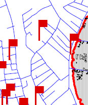
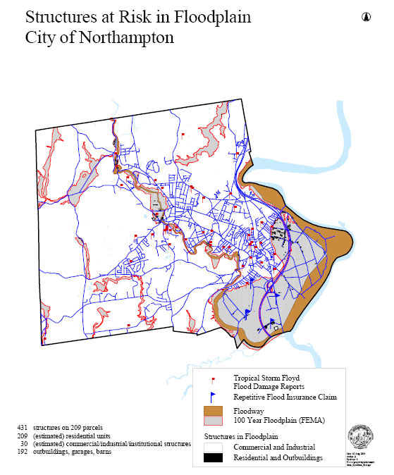
In the map below, the red flag behind View Avenue (the topmost flag) indicates a flood damage report from Tropical Storm Floyd (1999). This area is in the eastern portion of Kohl Construction’s proposed condo site, one of the more elevated portions. We infer that much of Kohl’s property may be at risk from heavy rainfall events.
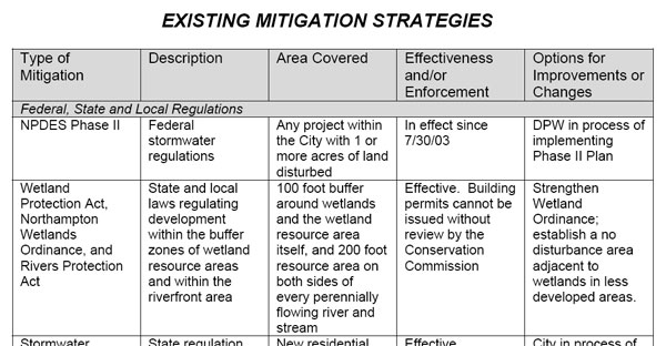
In a table of Existing Mitigation Strategies, the plan includes a “100 foot buffer around wetlands and the wetland resource area itself…” It says this strategy has been “Effective”, and says that an option to improve it would be to “Strengthen Wetland Ordinance”. This is a far cry from more recent assertions by Northampton planners that it has been a common practice in the city to allow developers to encroach as close as 10 feet to wetlands, and that the people should not be concerned if this practice is enshrined into law.
One of the “Priority Actions” is to “Consistently enforce the Wetlands Protection Act to maintain the integrity of the 200’ riverfront area, wetlands and wetland buffer areas.”
The plan specifically warns against building on Filled Wetlands:
Many areas of the City were developed before the passage of the Massachusetts Wetlands Protection Act of 1972. Historically filled wetlands are commonly related to problems with wet basements, flooding, shifting foundations and failed septic systems. Development in historically filled wetlands should be discouraged through zoning in order to protect health and safety. (p.24)
It is well known that some of Kohl’s land contains fill from work on Market Street, dumped there in the early 1980s. Kohl’s own Request for Determination of Applicability notes, “The wetlands are degraded with masonry and other construction and road building debris.” It seems plausible that parts of Kohl’s property meet the definition of a filled wetland.
The plan expresses concern for wildlife habitat, including vernal pools. “While areas containing significant wildlife habitat are not considered hazardous in the traditional sense of potential impacts to persons and property, when viewed in the larger context, it is land that is inappropriate to develop because of potentially long-ranging and significant impacts to the biological community and, in turn, to humans who are an integral part of it…” (p.24) Vernal pools are likely to be found on Kohl’s property. This will be investigated more thoroughly in the spring of 2008.
In general, a core problem for infill in Northampton is to avoid placing large numbers of people and structures in low-lying areas downtown that may be at risk for flooding. As the plan states, “In recent years, heavy rainstorms have caused significant problems in more urbanized areas as increased development inhibits proper drainage and existing or poorly maintained water systems cannot handle increased stormwater runoff.”
Here are more expanded excerpts from the plan, which foregrounds the importance of prevention in flood mitigation. We have emphasized certain passages with bold type.
When adopting the plan, the City Council noted that:
adoption of this plan will help eventually make the city eligible for a 15% flood plain insurance discount, make the city eligible for additional FEMA funds for flood hazard mitigation measures, including physical improvements, and set the stage for the land planning community involvement… (p.2)
The Preface of the plan states:
The City of Northampton has developed this Flood and Natural Hazard Mitigation Plan to address natural and manmade hazards and to plan for the future of areas prone to flooding. Flood hazard areas are found in the Meadows along the Connecticut River and along the Mill and Manhan Rivers. There is also localized flooding associated with the stormwater drainage system.
Northampton has experienced many flood events, resulting in over $1.5 million in damages related to flooding over the past 10 years, including $70 thousand the City spent to repair a fire truck that was damaged during Tropical Storm Floyd in 1999…
The intent of this plan is to develop a program of mitigation that goes beyond solely reducing hazard vulnerability and protecting property and taxpayers. The Plan also incorporates complementary goals that can help achieve multiple community objectives, such as preserving traditional land use patterns and open space, maintaining environmental health and natural features, and enhancing conservation and recreational opportunities. The Plan emphasizes the need to ensure that the City of Northampton becomes better able to withstand the forces of nature while at the same time improving the overall quality of life. (p.5)
The Background of the plan states:
Natural hazards can be exacerbated by societal behavior and practice, such as building in a floodplain and increasing the amount of paving in a watershed.
Northampton can experience flooding in any part of the City. One great misunderstanding is the belief that floods only happen in the floodplain. With sufficient rain, almost any area will experience at least pockets of surface flooding or overland flooding. Overland flooding in rural areas can result in erosion, washouts, road damage, loss of crops and septic system back-ups. Heavy rain in the more urbanized parts of the City with extensive paved and impervious surfaces can easily overwhelm stormwater facilities resulting in localized flooding and basement damage. Stormwater flooding also contributes to water pollution by carrying silt, oil, fertilizers, pesticides and waste into streams, rivers and lakes. As the intensity of development continues to increase, Northampton will see a corresponding increase in serious stormwater problems. It is therefore important that the City as a whole, not just residents of the identified floodplain, address the need for mitigation. Flood and hazard mitigation is any preventive actions a community can take to reduce risks to people and property and minimize damage to structures, infrastructure and other resources from flood or other hazardous events. Hazard mitigation and loss prevention is not the same thing as emergency response. Some flood loss reduction can be achieved by components of response plans and preparedness plans, such as a flood warning system or a plan to evacuate flood prone areas. However, warning and evacuation deal only with the immediate needs during and following a flood event. Hazard mitigation is much more effective when it is directed toward reducing the need to respond to emergencies, by lessening the impact of the hazard ahead of time. (Massachusetts Department of Environmental Management 1997, 3)
The process of mitigation planning, when ultimately incorporated into a land use plan, has the potential to produce long-term and recurring benefits by breaking the repetitive cycle of disaster loss. A core assumption in mitigation is that current dollars invested in mitigation practices will significantly reduce the demand for future dollars by lessening the amount needed for emergency recovery, repair and reconstruction…
When integrated into overall city planning goals, mitigation planning will also lead to benefits that go beyond solely reducing the costs associated with hazard vulnerability. Measures such as the acquisition or regulation of land in known hazard areas can help achieve multiple community goals, such as preserving open space, maintaining environmental health and natural features, and enhancing recreational opportunities… (p.5-6)
From “Developing a Mitigation Plan”
…It is necessary to find approaches to reducing flood and natural hazard damage that are simultaneously effective, equitable, economically reasonable and environmentally sound. Adoption and implementation of management strategies will depend on their ability to successfully mitigate environmental hazards while satisfying additional ecological and cultural functions, such as providing wildlife habitat and protecting open space. The City of Northampton can choose from and institute a variety of structural and non-structural hazard mitigation measures.
Structural measures may include drainage modifications, the construction of dams, dikes and other capital improvement projects that protect buildings and infrastructure from the forces of wind and water. Typically they are used to prevent a natural hazard from reaching property. Most structural projects are expensive to build and maintain and have other shortcomings, including the destruction of farmland and wildlife habitat and increased erosion downstream.
Non-structural strategies do not change the natural hazard, but involve preventative actions that improve infrastructure’s ability to reduce the damages, or improve coordination of resources. Non-structural measures include building codes and inspections, floodplain zoning, development regulations, acquisition of hazard-prone properties in fee simple or limited rights (such as Conservation Restrictions and Agricultural Preservation Restrictions), setting preferential tax rates for agricultural lands to discourage development in hazardous areas, open space preservation and wetlands protection.
A mitigation plan emphasizing non-structural strategies and wise land use policy can help ensure that Northampton does not increase its vulnerability through inappropriate land uses and encourage the acquisition, relocation or retrofitting of existing vulnerable structures along with the protection of valuable natural resources… (p. 7-8)
From “Goals for Hazard Mitigation”
A primary goal of the City of Northampton is to minimize exposure of people and property to flood and other natural hazards to increase public awareness of and responsibility for reducing flood losses. Working toward this goal will help to
- Reduce the costs suffered during floods and other natural hazard events
- Protect the interests of the City and all taxpayers
- Give landowners the opportunity to pay lower flood insurance premiums
- Maintain emergency services for the worst possible event
In order to meet this goal, the City must ensure that flood and natural hazard mitigation is adequately addressed in City regulations, particularly the Comprehensive Plan, Subdivision Rules and Regulations, Zoning Ordinance and Wetlands Ordinance, and that mitigation consideration is included in the evaluation and prioritization of public policy initiatives, such as public land acquisition.
Other City goals defined in Northampton Vision 2020, in particular preserving traditional land use patterns, preserving natural and cultural resources, and expanding open space and recreation, are complementary and support the purpose of hazard mitigation. (p.8)
In this table from page 9, the plan not only asserts that one of Northampton’s existing flood mitigation strategies is keeping a 100-foot buffer around wetlands, but that strengthening the wetland ordinance is an option for improvement:
…Priority Actions
Based on the above prioritization criteria, as well as an analysis of the current social, technical, administrative, political, legal economic and environmental feasibility, the following shall be considered priority strategies for flood hazard mitigation:
…Consistently enforce the Wetlands Protection Act to maintain the integrity of the 200’ riverfront area, wetlands and wetland buffer areas… (p.16)
APPENDIX A
Analysis of Flood Hazards in Northampton
…Major floods, such as those caused by heavy rains from hurricanes, and localized spot flooding can exceed the 100- and 500-year flood levels. In addition, many small streams are not mapped for their flood hazard… (p.18)
Flooding from stormwater runoff is a growing problem in every urbanized area and is caused by large amounts of impervious surfaces and by undersized or poorly maintained stormwater drainage infrastructure, including culverts and detention basins. Development not only creates more impervious surfaces, but it also changes natural drainage patterns by altering existing contours by grading and filling, sometimes creating unexpected stormwater flooding during heavy rains. Recently, the City of Northampton has seen flooding on Elm Street, along Church and Stoddard Streets, Bliss Street and Austin Circle due to undersized pipes and catch basins and lack of upstream detention that caused streams to jump their banks and flood roadways and properties.
Stormwater contributes to water pollution by carrying silt, oil, fertilizers, pesticides and waste into streams, rivers and lakes. Stormwater flooding also has the potential to cause considerable property damage because it occurs in areas of concentrated development… (p.19)
In this chart of significant floods in Northampton (p. 19-20), we note that Tropical Storm Floyd caused damage in the city comparable to or greater than that of the legendary Hurricane Diane in August 1955, underscoring the potential seriousness of localized flooding outside of the more obvious risk areas like the Connecticut and Mill River floodplains.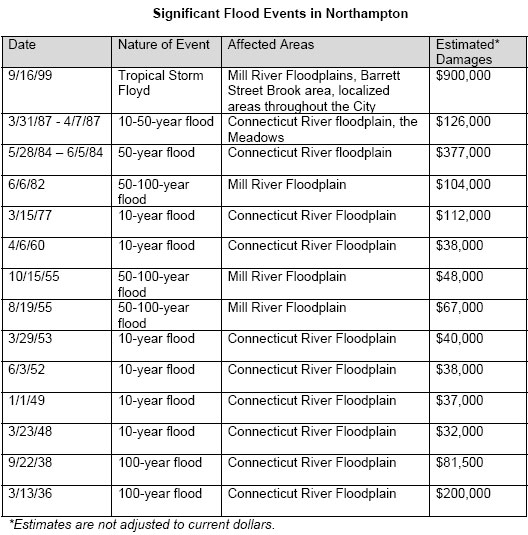
Flood Mitigation Measures
…Land use planning is a necessary and useful tool for addressing flood problems. Prevention of future problems through land-use planning and regulation is far more effective, permanent, and less expensive than trying to correct problems after they have been created… The City of Northampton administers planning requirements and regulations that work to reduce future flood damages by controlling the density, location, construction and type of development that may occur in the floodplain, environmentally sensitive and hazardous areas. The City also strives, and is seeking to improve, implementation methods that work to mitigate potential hazards… (p. 20-21)
Remaining Issues and Needs
During recent floods, flooding did occur to residences within the City that were not shown on the projected 100-year flood map, primarily along the Elm Street Brook and Barrett Street Brook. This level of flooding occurs with more frequency than a 1% chance in any given year…
Discouraging new development in areas prone to flooding is a necessary preventative solution to flooding… (p.22)
APPENDIX B
Environmental Limitations and Hazards Identification and Analysis
Wetland related problems
Filled Wetlands
Many areas of the City were developed before the passage of the Massachusetts Wetlands Protection Act of 1972. Historically filled wetlands are commonly related to problems with wet basements, flooding, shifting foundations and failed septic systems. Development in historically filled wetlands should be discouraged through zoning in order to protect health and safety… (p.24)
Wildlife Habitat
Some areas of Northampton contain critical wildlife habitat, including 29 state-certified vernal pools that support a variety of rare and endangered species. There are also 20 identified potential vernal pools.
While areas containing significant wildlife habitat are not considered hazardous in the traditional sense of potential impacts to persons and property, when viewed in the larger context, it is land that is inappropriate to develop because of potentially long-ranging and significant impacts to the biological community and, in turn, to humans who are an integral part of it… (p.24)
APPENDIX D
Additional Natural Hazard Identification and Analysis
Hurricanes
Likelihood of Occurrence
Virtually every area of New England, especially Massachusetts, has been affected by hurricanes. During the last 100 years, 20 hurricanes have passed within 125 miles of Boston. On average, the City of Northampton can expect a hurricane to pass nearby once every six years… (p.27)
Heavy Rainstorms
Description and Likelihood of Occurrence
In addition to flooding from hurricanes and northeasters, Northampton is also susceptible to flooding from severe rainstorms and thunderstorms. The occurrence of significant rain events in the City has been increasing over the past several years.
Vulnerable Areas and Populations
The greatest impact in the City is felt in neighborhoods along rivers and streams. In recent years, heavy rainstorms have caused significant problems in more urbanized areas as increased development inhibits proper drainage and existing or poorly maintained water systems cannot handle increased stormwater runoff.
The most recent example is the flooding following Tropical Storm Floyd, a 100-year storm that occurred in September of 1999 which created severe localized flooding conditions in the small flashy watersheds of the City, especially along the Mill River and the historic Mill River (both within and beyond the mapped Zone A), and along Barrett Street Brook and Elm Street Brook (both outside of Zone A). This storm caused approximately $900,000 in property damage.
Analysis
Much of the damage caused by heavy rains is the same as caused by stormwater and overland flooding. Flood hazard mitigation strategies discussed above will help to reduce impacts of heavy rainfalls… (p.28)
Earthquakes
Description and Likelihood of Occurrence
Although it is well documented that the zone of greatest seismic activity in the United States is along the Pacific Coast in Alaska and California, it may be surprising to most people that an average of 5 earthquakes are felt each year somewhere in New England…
Vulnerable Areas and Populations
In the event of a major earthquake affecting the City of Northampton, the damage would likely be greatest in areas of filled land, which can increase ground shaking intensity… (p.29-30)
APPENDIX E
In the chart below, we observe that flood damage from Tropical Storm Floyd was reported at the end of View Avenue, in the eastern portion of Kohl Construction’s condo site. (p.36)
See also:
Kohl’s Condo Proposal: Where Things Stand, and What You Can Do
Kohl Construction proposes to build 31 condo units in the forest between North Street and the bike path. This development, with its access roads and 66 parking spaces, will claim 5.49 acres of land….
A wetland centered on Millyard Brook runs through the heart of the forest. The buffer area around a wetland is important in itself, an edge zone of high species diversity that helps regulate water flows into the wetland. These areas are fragile, can take a long time to establish, and are easily disturbed by development. The consequences of development around wetlands are often increased floodin
g in wet periods and more severe dryness during droughts.
As Hurricane Threat Builds, Has Complacency Set In about Flooding?
Infill sounds great on paper, but when it means paving over green space in downtown Northampton, it runs contrary to sound flood mitigation practice. The reality is that much of the remaining green space in downtown is in low-lying areas that are most susceptible to flooding. It makes sense to go along with the collective wisdom of the past 350 years and leave them undeveloped.