Here is a Google video of “Low Impact Development: Performance Results and Implementation in the Field”, a presentation from the Smart Growth – Smart Energy Conference 2008, a conference held on 12/12/08 at the Boston Convention and Exhibition Center. This presentation includes a comparison of the merits of various stormwater management systems. Some are much more effective in winter than others. The video is 1 hour and 2 minutes long, and was recorded by Adam Cohen.
Here is the program description of the session:
Session B-7
Low Impact Development: Performance Results and Implementation in the Field
From
the increasing usage and research on Low Impact Development (LID)
techniques, we are developing a better understanding of how to select
the most appropriate BMPs for stormwater management projects.
Appropriate application of LID can be particularly challenging in
redevelopment areas affecting impaired waters. Speakers will discuss:
1) the performance of LID techniques from comprehensive literature
reviews incorporated into a web-based tool; 2) on-site testing at the
UNH Stormwater Center focusing on seasonal variation and cold weather
performance; and 3) implementation choices and challenges in the
Ipswich watershed.Moderator:
- Eric Hove, Acting Director of Land Use Policy, Executive Office of Energy and Environmental Affairs
Speakers:
- Robert Roseen P.E., PhD, Director, University of New Hampshire’s Stormwater Center
- Sara Cohen, Water Resource Specialist, Department of Conservation and Recreation
- Jerry Schoen, Director of the Massachusetts Stormwater Technology Evaluation Project, University of Massachusetts-Amherst
Here are selected excerpts from Dr. Roseen’s presentation (0:13:30-0:32:12):
0:15:26-0:15:36: “Research in the 90s has shown that most stormwater treatment devices fail some portion of the time, say, two-thirds of the time, for some water quality constituents.”0:16:12- 0:16:32: “The wet ponds in general do perform…reasonably well [on water quality metrics]. The dry ponds don’t do very well at all. And the swale really has no pattern of performance. That represents 95-96-97 percent of our stormwater management today. That explains much of our current water quality woes.”
0:23:36-0:27:59: Summer vs. winter performance of various stormwater systems. Pointing to a chart showing removal of total suspended solids (TSS): “So here’s our [stone-lined] swale. This is probably 98% of what’s out there. It’s doing fine in the summer. It does nothing in the winter.” “If you consider the EPA is in general is looking at 80% removal efficiency for TSS, our conventional practices [such as stone-lined swales and wet ponds] are not meeting that.”
0:29:36… “How are you going to balance public safety with aquatic habitat? We know we’re going to go with public safety. So, salt reduction is not the simple answer… and there’s no way to treat salt with a stormwater BMP.” Roseen goes on to recommend consideration of porous pavements. They let you use less salt and still prevent slippery surfaces.
Kohl Construction’s application (PDF) to build condos near the wetlands off North Street provides a Stormwater Drainage Report and a Stormwater Management Plan (pages 27-185). In light of Dr. Roseen’s research findings, the winter performance of Kohl’s proposed stormwater systems needs much more analysis. Not only is water quality an issue, but also flood control, as ice, snow and slush are well known to impede the smooth flow of water.
On page 152 of the application Kohl asserts, “The use of sand or deicing materials shall not be excessive.” Since public safety is generally top priority in practice, however, this seems like a thin safeguard for water quality.
For all these concerns, a cost-effective and durable solution is to keep impervious surface, disturbance and compaction within 50 feet of wetlands to a minimum. This strategy of natural flood control was recently employed by the Army Corps of Engineers for the Charles River:
Wetlands are major flood-control agents in the
watershed of the Charles River, which flows through Boston. Larson
observes that when the Corps of Engineers arrived to investigate the
flooding problem, it was raining heavily, and they saw the marshes
filling and “acting as natural flood controls. The rain was after a dry
period — and the water went downstream over three weeks rather than
three days.”After calculating the cost of creating that amount of
storage with dams, Larson says the Corps concluded it “would be a lot
less expensive to buy 8,000 acres of natural wetland, and to use
conservation restrictions to buy up development rights” on other
floodplain acreage.
See also:
Kohl Construction Applies for Special Permit and Site Plan Review
“Innovative Non-Zoning Approaches to Encourage Smart Growth and Protect Public Health” – Video with Wayne Feiden and Bruce Young
1:03:00… [Bruce] Young: “We have some serious challenges
ahead of us. And one is… ‘HIGs’, holes in the ground. And so, what
we’re saying is, we want good infill development, but through our
Wetlands Ordinance we didn’t really adopt stormwater standards that
would improve the stormwater in these infill areas. So we have a
challenge to come up with better design standards for stormwater
instead of these giant holes in the ground, and to actually require or
implement some, or incentivize some low-impact development type of
stormwater systems. And then…the second thing that goes with
stormwater systems is maintenance… We’re working with the Department
of Public Works that now has a stormwater manager and we’re setting up
maintenance for these systems, but some of these are older systems and
some of these have been approved under a system that didn’t have
basically [what’s modern] for these types of systems…
Video of December 11 Kohl Condo Hearing at Conservation Commission
Kohl proposed to place grading, walls, yards, patios, and certain components of the stormwater
management system as close as 12 feet to the wetland
on its parcel… The commission expressed discomfort with allowing much disturbance closer than 35 feet to the wetland…
…Commissioner Downey Meyer, “I’m…not inclined to go below 35
feet. I also wonder why those who have spoken so quickly got to 50,
since the state Wetland Protection Act and the city ordinance both
protect to 100. So I think you’re being rather unambitious arguing from
50 to 35… I’m also, as Alex said, a little bit skeptical of the
engineered solutions… Part of the reason why buffer zones have
received greater emphasis in wetlands protection is that they do seem
to work without anyone having to maintain them in terms of making the
whole wetlands system work effectively.
Alex Ghiselin, Letter to Gazette: “Don’t let development encroach on our wetlands”
The
failure of the storm water system built as a part of the Northampton
High School renovation six years ago illustrates why protecting
wetlands is so important. Silt has filled the retention pond so there
is no capacity to slow a storm surge which now flows unimpeded into the
Mill River and contributes to flooding downstream. This accumulated
silt also raised the water table and spills ground water into nearby
basements…
Without maintenance, these [storm water mitigation] systems are part of the problem, not the solution…
Wetlands do not need to be maintained; they just need to be protected.
Maintaining Stormwater Management Systems
“The
number-one problem we saw in stormwater quality was that no one was
maintaining anything,” Moll [John Moll, chief executive officer of
Lawrenceville, GA–based CrystalStream Technologies] notes. “We’d ask
people, ‘How do you clean these things?’ And they had nothing. Now,
it’s gotten better. But there is still a lot of work to be done.”
…[Some] owners
assume they will stay in compliance simply by cleaning the BMPs—or
scheduling a cleaning—every year or every six months. Problem is, some
BMPs don’t need that much cleaning, depending on the type of stormwater
device and its location, Jacobson says, while others may need cleaning
much more frequently.
Easthampton Flooding Hazard: Snow-Clogged Storm Drains
“If the water has nowhere to go, it’s going to find somewhere to go… The slush really clogs [storm drains].”
Snow and Slush Expose Limits of Storm Drains
…”The rainfall carries floating slush to a catch basin,” said Amherst
Public Works Superintendent Guilford Mooring. “We clear something up
and it clogs up again. We’ve been working since last night.”
Ditto
for Easthampton Public Works Superintendent Joseph I. Pipczynski: “It’s
just a nasty storm,” he said. “You unplug the basin, they go down the
street, the slush covers the basin again and you’ve got another lake…”
Evaluation of LID Stormwater Treatment Systems (PDF)
James Houle, CPSWQ, Robert Roseen, PE, PhD, Thomas Ballestero, PE, PhD, PH, CGWP, PG. Presented at the Merrimack Valley Planning Commission Conference in Haverhill, MA on June 5, 2008.
Page 48: “Seasonal Variations in Performance”
A vegetated swale will remove over 60% of total suspended solids and 90% of zinc in the summer, and less than 20% of either in the winter.
Page 52: “Chloride”
“Chloride is toxic to aquatic life”
“No BMP targets removal”
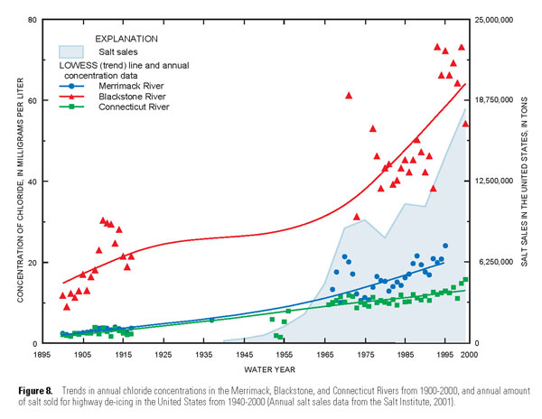
U.S. Geological Survey, “Water-Quality Trends in New England Rivers During the 20th Century” (2003, chart from page 22)
Paved Surfaces, Salt and Water Bodies: A Bad Mix
All of the homes that have salt contamination in their wells are on
Route 10, which is treated with road salt by the state Highway
Department, said Anne M. Capra, a principal planner with the [Pioneer
Valley Planning Commission]…
Gazette: “Salt suspected in Southampton well contamination” (2/19/08)
According to the U.S. Environmental
Protection Agency’s Web site, salt is a cheap and effective solution to
ice-covered roads that can be a problem for drinking water systems as
runoff affects local soil quality, groundwater and surface water
supplies…
Polluted Runoff Helps Trash Two Ponds in South Hadley
As The Sustainable Sites Initiative reports, pollution from water runoff is no joke. “Contaminated stormwater runoff from developed land is the leading cause
of water quality problems[23] and accounts for 70 percent of water
pollution in urban areas.[29] Runoff from developed areas can contain
oil, grease, excessive nutrients, pathogens (e.g., E. coli, hepatitis
A), persistent bioaccumulative toxic (PBT) chemicals, and heavy metals.”
Today’s Gazette
contains a guest column from Thomas Wallace. He lives next to the Back
Stevens Conservation Property in South Hadley. Its upper and lower
ponds used to feature clean, clear waters used for mill operations and
ice making. Later it supported fishing and passive recreation. Those
days are gone…
Performance of Stormwater Management Systems (PDF)
James Houle, CPSWQ, Robert Roseen, PE, PhD, Thomas Ballestero, PE, PhD, PH, CGWP, PG. Presented at the Northeast Ohio Stormwater Conference, Cleveland, OH on May 22, 2008.
Page 5: “Impacts of Development aka impervious surface”
Stable: Up to 10% watershed impervious cover, stream health good
Impacted: Up to 25% watershed impervious cover, stream health fair
Totally Degraded: Over 25% watershed impervious cover, stream health poor
Page 42: “Seasonal Performance Trends”
A bioretention system removes over 70% of dissolved inorganic nitrogen (DIN) in the summer, and less than 40% in the winter. A retention pond removes over 70% of DIN in the summer, and less than 50% in the winter.
Page 52: “Chloride Levels in First Order Receiving Stream (Durham, NH)
Chart shows chloride concentrations spiking over acute toxicity levels three times during Feb-Mar 2007.
Page 53: “Where should reductions occur?”
Chart shows parking lots are responsible for 50% of the “salt loading from vehicular surface deicing” in Rockingham County, NH (NHDES 2007).
Page 69: “Municipal Infrastructure Replacement”
“Recent research examining impacts of climate change on rainfall depths demonstrated existing urban infrastructure are under-capacity by 35%”
Update from Notre Dame; Critique of Northampton Sector Diagram
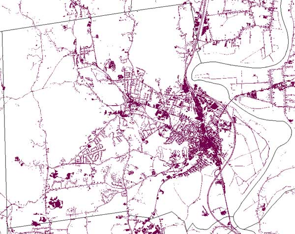
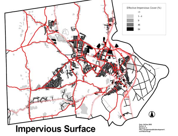
These charts show the degree to which impervious surface already overspreads the “receiving areas”. The first chart is from OLIVER, The MassGIS Online Data Viewer. The second chart was prepared by Northampton’s Office of Planning and Development.


City Council Enacts New Wetlands Ordinance, Including 10-Foot Buffers
…our in-town buffers are more important than average when it comes to flood mitigation and water pollution. A disproportionate percentage
of the people and property of the city are found in the areas now
subject to 10-foot wetlands buffers. Our drainage systems there are
already under stress. Flood damage reports from Tropical Storm Floyd show clusters of red flags in our urban areas, even under the previous, more restrictive buffer zone regime.
It
also stands to reason that stormwater runoff, with its chemicals, oils,
sand, silt, and other contaminants, is a more serious issue in our more
urban areas, with their large concentrations of human activity, cars
and impervious surfaces. Narrow wetlands buffers will enable that
pollution to enter our streams and rivers more quickly, with less
processing, and in higher volumes. This runs contrary to the spirit of
the Connecticut River Strategic Plan
(2003), which “proposes the removal of impervious surfaces within 50
feet of streams…” As former Councilor Alex Ghiselin observed during
the public comment period, cleaning up the Connecticut River has been
one of the region’s signal achievements during the past generation.
It’s a shame to imperil this work.
Connecticut River Watershed Action Plan: Remove impervious surfaces within 50 feet of streams
To
reduce nonpoint source pollution from stormwater runoff, the
Connecticut River Strategic Plan proposes the removal of impervious
surfaces within 50 feet of streams and the investigation of “functional
replacements” (such as the use of permeable pavement) for impervious
surfaces within 100 feet of streams, in developed areas (PVPC, 2001).
In the urbanized areas, the removal or retrofitting of impervious areas
and the implementation of Stormwater Best Management Practices (BMPs)
could be beneficial in improving water quality.
Photo Essay: Millyard Brook Swells with Water in Winter (1/12/08)
On
January 11, a mild and rainy day, Millyard Brook is clearly not dry,
but helping a large volume of water flow safely through the
neighborhood. Adding impervious surface near streams like these can
increase the speed and volume of runoff that flows into them and make them more flood-prone. In addition, the pollution from developed areas (e.g. salts, oils, herbicides) can harm the vegetation. As the City of Northampton acknowledges,
“Problems with nutrient runoff, erosion, siltation, loss of groundwater
recharge, poor water quality, vegetation change and harm to wildlife
habitat are greatly exacerbated by activities within 100 feet of
wetlands…”